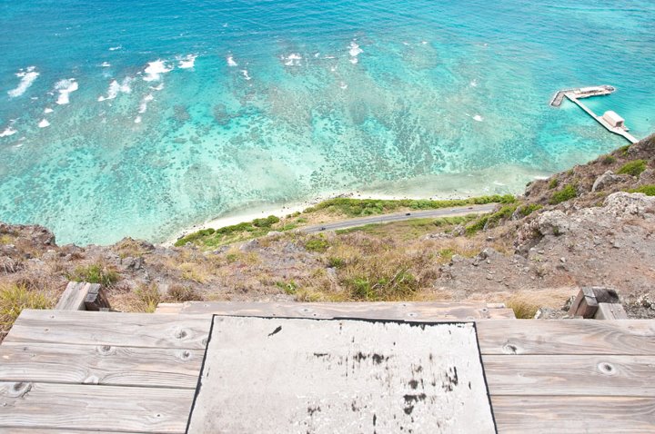
For a long time I believed that Mariners Ridge had to be the easiest route to the Koolau Summit. Well, I was definetly wrong. Kamehame Ridge, located in the back of the Kamehame subdivision in Hawaii Kai, is by far the shortest and easiest way to access the Koolau Summit that I am yet to have found. It took me about twenty minutes to reach the top of the ridge and about ten minutes to get down, all while moving at a pretty casual pace. My guess would be that the entire trek is less than 2 miles round trip. The hike up was via a gravel road that we followed all the way to the top of the ridge. As the gravel road ended we were greeted by a fence. We headed just to the right and to the cliffs edge and were greeted by the sensational views of the blue and aqua colored waters of Waiamanlo Beach. We took in the views and I was very pleased that the sun was beaming down on the ocean, making the color of the water look even more impressive. Unfortunately the clouds rolled in shortly after, and the gleaming colors of the ocean dissapated a little, but the views were still jaw dropping.
By heading left or right at the fence line where the gravel road ends you will be able to head further up the ridge (this is of course optional) and shortly after will reach an old missile silo that serves as a cellular phone tower site now. It's an interesting place to walk around and you can climb up the towers and walk into the buildings if you really want. Heading further up the ridge will take you to Kamiloiki Ridge eventually and the Makapuu Tom-Tom junction that heads down into Waimanalo. Also, from where the gravel road ends, if you back track for about a minute, just before you arrive back at the building that you saw on your right hand side on your way up (this is a rehabilitation center for young teens trying to get their lives back on track, from what I have gathered) you will encounter some pink ribbons and a trail on the ocean side, heading up. If you follow the trail up for about twenty seconds, you will then come to some concrete stairs, which will take you to the hang glider launch pad after about another thirty seconds. This is where a lot of the hang gliders you see over Makapuu, launch from. There will be a green astroturf platfrom that will mark the launch pad. This is a great, open area to sit and admire the beauty of what is now in front of you. Grab some water, talk story, and soak it all in before heading back down to the start of the trail.
In the past I had heard stories if this being on private property and it being a no trespassing trail. When I arrived at the gate on this day, there sure enough, was a no trespassing sign on the gate and just to the right of the gate was a security car with a guard inside of it. With my friends from out of town with me and wanting them to be able to do a short and non time consuming hike, I decided to walk up to the security guard and ask him if I could go up. When I did so, I was very surprised with his response. He told me, "you can go if you'd like, I'm not gonna stop you". He then smiled, started his car and drove away. We of course grabbed our stuff and headed up the gravel road. As we were walking up the road a service car was driving down. We inched our way to the right side of the road so he could pass but I couldn't help but feel a little worried about getting chewed out or told to leave. As the man drive by with his window down, I threw him the shaka, he smiled and waived and said "have a good day", and then proceeded to the gate, which he opened, drove through and then left. I'm not sure if you are suppose to be on this trail or not but from my experience on this day, it doesn't seem that anybody really cares. I think the key is to just be respectful and quiet and if someone does stop you, just simply say i'm sorry and tell them you will leave and then do so. I really don't think anyone should have problems accessing this trail though. I think the property belongs to Kamehameha Schools and that they have now leases the property out, but I don't know this to be a fact. With all that aside, this is a stroll that is suitable for kids of all ages and would be a hike that I would recommend for anyone whos cardio is not the best and who is just beginning hiking hear on Oahu. The views all along Makapuu Ridge are some of my favorite and the views along this stretch are no different. This is a great bang for your buck hike.
Directions: Head East on Kalanianaole Hwy as if you were going to Hanauma Bay. You will want to take a left onto Lunalilo Home Road, just before actually reaching Hanauma Bay (you will now see Koko Crater just in front of you). Next you will want to make a right onto Hawaii Kai Drive. After that turn left onto Maunanani Street, followed by a right onto Kamehame Drive shortly after. Drive all the way to the end of Kamehame Drive and park along the street. Where Kamehame Drive dead ends, there will be a little gate with a no trespassing sign on it. Walk around the gate and follow the paved gravel road to the top of the ridge.
Makapuu Tom-Tom is an adventurous 4 mile ridge hike located on the eastern side of Oahu that starts at the Makapuu Lookout and ends in a little neighborhood in Waimanalo. Makapuu tom-tom was named after Tom Mcguire and Tom Cadle, who rediscovered the old Hawaiian trail that connects Waimanalo to the Koolau Summit. The views one will get of the stunning ocean colors along this trail are hard to beat.
The Makapuu Tom-Tom trail starts at the Makapuu Lookout parking lot just past the parking lot where everyone parks for the Makapuu lighthouse hike. You will need two cars for this hike because you will be exiting in Waimanalo via the tom-tom trail and will need a car stationed there to bring you back to your car at the makapuu lookout. Our friends staged their car behind the 7-11 in Waimanalo (you can park in the neighborhood in Waiokeola, right where the trail ends also, but the residents over there tend to get a little testy) and then we drove them back to the makapuu lookout where the rest of our crew was waiting for us to begin the hike. We darted straight across the road at the lookout. Once on the other side of the street, a faint trail became clearly visible. If you can not see it just head towards the fenceline that hugs the cliffs edge to the right and follow the fenceline to the top of the hill. Immediately after reaching the top of the hill beautiful views of manana (rabbit) and kaohikaipu island and makapuu beach came into view. The colors of the ocean amazed us and yet they just got better and better as the hike went on. Once at the top of the hill we headed right and towards the cliffs edge and picked up a faint trail. The trail is kind of hard to find at points but as long as you remember to stay near the cliffs edge you shouldn't get lost and the trail should always come back into view.
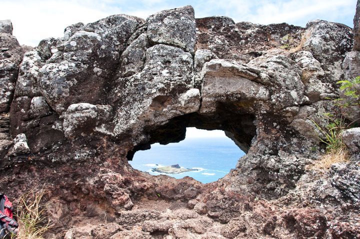
This hike has a lot of ups and downs and is pretty long (four to seven hours, so bring plenty of water and food) but overall it is not all that taxing on the body. Not to long after we started following the ridgeline along the cliffs edge we arrived at a puka (hole in the rocks). A few of us climbed inside of it and took some pictures, but I would suggest being very careful if you do this, for if you fall it will certainly not be a good outcome. Views from the rocks above the puka and picture taking from this point are great. From the puka we followed the trail as it periodically narrowed to our right and began climbing up a rock face to the next peak that was visible. There are a few different routes that one can take and on this day we all seemed to be going our own way and climbing up the rock face at the same time from every which angle. The climbing is not very technical and is more fun than challenging. In Stuart ball's "The Hikers Guide to Oahu" he writes that the Makapuu tom-tom trail is for those that love to scramble. He could not have been more right.
After a little bit more climbing and scrambling we all finally arrived at a platform with green astroturf on it. This is the hang glider launching pad. The hang gliders will often come to this very spot and then jump off. Kind of crazy if you ask me, but they seem to enjoy it. It's awfully cool to see them gliding through the sky but there is no way you could get me to jump off that little platform. From the launching pad platform we walked down the concrete steps and were greeted by an access road. Once on the access road we walked towards the top of the road and when we saw a huge concrete slab (on our right side) we took a right and headed for the cliffs edge. Just after making the right there was a little fence that we all had to maneuver around to get back on to the trail. If you are affraid of heights you will absolutely hate this part. Everyone in our group but one of us managed this part with no trouble and then we slowly coaxed our other friend to the point where we were waiting for him at.
Once we had safely maneuvered around the gate we followed the easily identifiable trail and next we came to an old missile site that is now used as a cell phone tower site. We saw a set of stairs and headed up those stairs after playing at the missile site for a few minutes. All of the old, tall military structures make this part of the hike very interesting. The trail from here is easy to follow and the next part of the hike consisted of a steep climb down a rock face. There was a rope and cable in place here to aid us in our descent but it was not that hard of a climb and the ropes weren't really needed. For those in the group that were a little uncomfortable, we just had them slowly slide down on their butts while holding the rope. After making it past this section there was a narrow contour section that we had to follow to arrive back on the ridgeline, but the trail is alway apparent. We followed the now semi-narrow ridgeline along the cliffs edge and then after another short climb up a little rockface, we arrived in a shaded area with some ironwood trees and were greeted with an absolutely amazing view of Waimanalo and Olomana in front of us with Konahuanui in the background and the rest off the koolau summit just off to our left.
From this spot the trail was wide and easy to follow but a junction came in on our right hand side (it should be ribboned) that we needed to follow. I was in front of the rest of the group and of course missed the junction and ended up heading down to the left into a wooded area with pine needles everywhere. I eventually realized that I was on the Kamiloiki trail and that I needed to backtrack. The rest of the group was looking for me at this point and was way ahead of me. Luckily a few of them backtracked and pointed out the junction to me. To prevent this from happening to you just remember that you need to get back on the cliffs edge after leaving the knoll area with the ironwood trees and just continue to stay on the Koolau Summit Trail. After taking the correct juntion, the trail once again stayed true to the cliffs edge. There was a few more rock climbing sections and ups and downs but nothing to crazy. We entered another wooded area at one point and went straight down only to come out of the wooded area and have to start our ascent back up once again. From this point, the end was in sight. We kept scrambling and climbing and we eventually reached a peak with an electrical pole on top of it. After going a little bit of a ways past the electrical pole we saw a trail on our right hand side (it had pink ribbons to mark the way) heading down into the valley.
We took this right and were officially on the tom-tom trail. I expected the trek down the tom-tom trail to be incredibly easy, but it wasn't as easy as I had originally anticipated. There are a few technical parts where you have to climb or negotiate steep and narrow sections. Everyone in the group made it down this ridge pretty quickly but one of my friends was having a tough time and was not enjoying the exposure and descent down, so I stayed behind with him and watched as he basically crawled down the entire ridge. This was fine by me and I told him just to make sure that he was comfortable and to be safe. I was starting to get a little worried about time and was hopeing that we wouldn't get stuck on the ridge after sunset since I mindlessly didn't bring any headlamps or flashlights (always have a headlamp or flashlight with you) with me. Luckily the ridge eventually leveled off and we entered a wooded area and the exposure was no more. We were almost home free. I told my friend that I was sorry and that he didn't have to hike with me anymore. I truly did not know that he was affraid of heights when we had started the hike. He seemed to be more upset with his girlfriend than me, since she pushed him to come. Now that he knew that he was in the clear, he relaxed a little bit and his anxiety started to go away. I thought that he was gonna kill me but he actually thanked me. He was so happy to have completed this trail and to have had this experience and to have accomplished something that to him, was a huge feat. I was incredibly inspired by him and and his determination to finish this trail. A few times during our descent he made comments about wanting to call rescue and I started to worry. I've never had to do that before and i'm glad this day was not the first time, because it would have been solely on my head and an embarassment that I would have never been able to let go of. Once we reached the wooded area we both talked and joked in within ten or fifteen minutes we had reached the neighborhood in Waimanalo where the rest of the group pulled up in the car to get us (having already walked to the car and driven the others to their cars back at makapuu - wow).
Hiking the tom-tom trail taught me that just because something is easy to one person doesn't mean that everyone will see it that same way. We all have different hiking levels and different things that hold each of us back and we need to be aware of these things when we hike with others. My friend stated to me that he had always wanted to hike in the mountains here before he left to move back to the mainland and that he was so happy that we helped him achieve this goal. All though I love hiking and I do it regularly, I realized that not everyone is as passionate about hiking as me and that not everyone indulges on the trails the way I do and that I need to be more aware in the future of who I am with and where we are going, for their safety and for my conscience. I learned many lessons on this trail that I will assuredly use on many hikes in the future. I was just glad that at the end of the day, we all got down safely and were able to laugh and high five while drinking a few slurpees outside of 7-eleven before heading to the comforts of our own homes.
Directions: Pretty simple. Park one car at the makapuu lookout and one somewhere in Waimanalo (I suggest parking behind the 7-11 and when you finish the hike just walk to your car, but you can also park somewhere on Waiokeola street where the hike ends, but i've bad stories about people who leave their cars parked there). To get to the Makapuu Lookout (from waikiki) take the H1 to Kalanianaole Hwy and continue past Hanauma bay and the halona blowhole and eventually you will pass the big parking lot where everyone parks for the Makapuu Lighthouse hike. The Makapuu Lookout will be on your right side just after this. Park there. To park your second car, continue straight on Kalanianaole Hwy until you reach Huli street. Take a left on to Huli street and follow it until it connects with Waiokeola street. Take a left on Waiokeola street and where the road dead ends is where you will exit from your hike via the tom-tom trail. Park anywhere in this area that you feel comfortable. To park in the back of the 7-11 where I parked, just continue past Huli street and the 7-11 is right off the highway just after Huli street. If you do this, when coming off the tom-tom trail, proceed down Waiokeola street, take a right on to Huli street, a left on to Nakini street and then that will take you back to the hwy where you will take a left and the 7-11 and your car will be right there.
Two nights before thanksgiving a group of us had hiked at night to Puu O Kona. After this hike, which took us late into the night, I had no plans of hiking until after Thanksgiving but as I was sitting and watching tv at around 10pm on Thanksgiving Eve when I recieved a call from one of my buddies who had joined me the night before on the Puu O Kona adventure. He was inquiring to see if my wife and I were interested in hiking that night at about 11pm. I could do nothing else but laugh and merely told him that I just didn't think it was going to be possible for us to join him. To my amazement, my wife quickly jumped up and said "lets go!" After seeing my wifes enthusiam about hiking on this night, I figured why not. We finished what we were doing and waited for my buddy to pick us up.
My friend arrived at my house shortly after 1030pm and we quickly headed down the highway and off to his other friends house, who would always be joining us on the hike. After picking her up we drove past Hanauma bay and shortly afterwards reached the Makapuu lookout where we parked the car. We wasted no time in starting. Instantly after parking we all ran across the highway and headed straight up the hill, following the fence line to the top. Once at the top, we veered right and continued to follow the ridgeline along its edge. This was probably the hardest hike i've done at night. It was not very strenuous (I actually hiked it in sandals) but it was very hard to find the trail and to follow in a few spots. The views were not all that great because we were not at a very high elevation and there were not many houses or city lights in the area beneath of us. Looking at the lighthouse beaming directly in front of us was pretty neat however. Our goal was to hike to the puka along the ridge and then hang out there and get some pictures and then to come back. Doing this would take a few hours in itself but for the really good views and pictures we would have had to hike up the mountainside another hour or so to get to the hang glider launching pad where the views to the city beneath open up. Since it was alreay late we decided against this. No reason to do that long trek when we could just go hike the shorter Kamehame ridge to the hang glider launching pad on other night.
We continuously weeved in and out of brush along the mountainside, trying to avoid the cacti plants that would present themselves every so often. After emerging from the brush, the trail stayed true to the cliffs edge the rest of the way with a few easy rock climbing parts before we eventually reached the puka above Sea Life Park. The four of us spent an incredible amount of time taking pictures and just goofing off and enjoying each others company. The wind was not blowing to hard so me and my buddy took turns climbing in to the puka for photo ops. This was maybe the funnest night hike i've done as of yet. We did get some views of the city lights on the other side of the mountain and the clouds were lit up on that side. We all sat in awe of the beauty and took as many pictures with the tripod as possible.
After an extraordinary amount of time spent at the puka, we all packed up our stuff and began our journey back down to the lookout and our car. Unfortunately, on the way back I missed our junction and we ended up scratching and pawing our way through thick brush to reach our car. Not even this mistake and my scratched up body could put a damper on this night. Not even the fact that it was after 3am could bother me. There is nothing like a good hike on thanksgiving night or morning to remind one of what you are truly grateful and thankful for. Nature, family, and friends. I could not have asked for a better start to my Thanksgiving holiday.